
Greenland Ice Mass Loss 2002-2021

This resource has been reviewed by SubjectToClimate's climate scientists and verified for scientific accuracy and up-to-date information. Learn about our review process →
Provided by: NASA|Published on: April 27, 2021
VideosScientist Reviewed
6789101112
Scientist Reviewed This resource has been reviewed by SubjectToClimate's climate scientists and verified for scientific accuracy and up-to-date information. Learn about our review process →
Synopsis
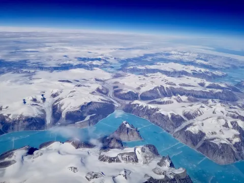
- This video from NASA shows a map of Greenland's ice loss over time next to a graph displaying ice mass loss in gigatons per year from 2002 to 2021.
- Students can engage with this video and use it as an interactive data set.
Subjects: Earth and Space Sciences
Authors: NASA
Region: Polar Regions
Languages: English
Teaching Materials
Positives
- The short video is a quick introduction to ice loss in Greenland.
- The color coding on the map of Greenland clearly shows areas with the greatest amount of ice mass change.
Prerequisites
- Students should know how to read a simple graph.
- Teachers may want to provide some context before or after the video, as there is no narration or sound.
Differentiation & Implementation
- Advanced students can attempt to continue the graph to make predictions about future ice loss.
- This animated graph and map can be used in social studies classes when discussing the effects of sea level rise and the many communities that are threatened by sea level rise today.
- Science classes can use this short video when discussing the global effects of greenhouse gas emissions and the feedback loops associated with losing ice that would otherwise reflect a significant amount of solar radiation.
- Math classes can use the video when learning about graphing data.
This resource visualizes the loss in ice mass of the Greenland Ice Sheet since 2002 as a result of anthropogenic climate change. This resource is recommended for teaching.
Teaching Tips
Standards
Resource Type and Format
Scientist Reviewed
This resource has been reviewed by SubjectToClimate's climate scientists and verified for scientific accuracy and up-to-date information. Our review process ensures that every resource in our library reflects the current state of climate science.
Learn about our review process →